

Important Bird Area: Lee and Cole Rivers
Site Summary
Nominated By
Mark Lynch, Shiela Carroll
Size
9,500 acres
Towns and Counties
Somerset, Swansea; Bristol
Ownership
municipal, private
Major Habitats
coastal beach, marine/tidal, river/stream, urban/suburban
Land Use
hunting & fishing, utility right of way, urban/ industrial/ commercial
Serious Threats
residential/commercial development, water/air pollution
Minor Threats
disturbance to birds or habitat
Site Description
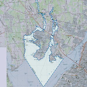
The IBA includes the Lee and Cole rivers to the north of Route 6 and the shorelines, marshes, and flats of these rivers directly south to the Rhode Island border. These two rivers empty into Mount Hope Bay above the Rhode Island border on either side of a small residential peninsula called Gardner's Neck. The area is in extreme southwestern Somerset and southeastern Swansea, the border between the two towns running down Lee River. The area is very residential and industrial. It area has tidal river flats merging into coastal bay habitat. There is little emergent vegetation except Common Reed combined with typical grasses on coastal mudflats. Most of the shore is privately owned and heavily developed. A long sandy spit runs west into the Cole River from Gardner's Neck and contains a beach. Huge concentrations of geese, dabbling ducks (surface feeders in shallow water), and "bay ducks" (diving species in ponds, bays, etc.) over winter here as well as large numbers of Horned Grebes. This IBA is not well known and documented since it's undercovered by birders.
Current Conservation Status
There are no preserved areas within the site, except for the small Ocean Grove Beach. An enormous cool-powered plant, the Brayton Point Power Plant, which was called among the "Filthy Five" most polluting power plants in Massachusetts (www.healthlink.org), occurs on one side of the site. Boats are regular in the area and may disturb waterfowl. Recognition as an IBA may be one more step toward helping to clean up and preserve this important area for migrant waterfowl.
Ornithological Significance
Large numbers of waterfowl overwinter in the immediate area including: Horned Grebes (85 in 2002), Greater Scaup (4,500 in 2001), Brant (1,500 in 2002), Canada Geese (1,312 in 2000), Mute Swans (124 in 2000), Gadwall (51 in 2000), and American Black Ducks (260 in 2000). Lesser numbers of Hooded Mergansers, Red-breasted Mergansers, Common Goldeneyes, and Buffleheads, were also observed. The largest concentrations of dabblers are found in the upper Lee River. Huge numbers of geese have been observed in both rivers, and large flocks of Scaup and Brant were observed at the lower reaches of both rivers. An Osprey platform is also in use. Exploration and recording of waterfowl in this area need to be expanded.
Data Sources
M. Lynch, personal observations and systematic counts: 1999 to 2002.