

Breeding Bird Atlases (BBA)
Find a Bird
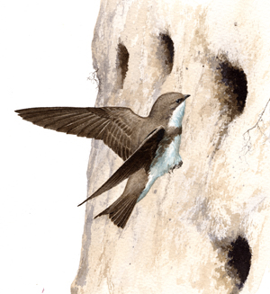
Bank Swallow
Riparia riparia
Somewhat local and strongly declining
Conservation action urgent
“The sociability and gentleness of these birds, the lightness and vigour with which they perform their various evolutions, the low and unobtrusive twittering of their voice, in short, all their actions and economy, are delightful to contemplate.” – John James Audubon, Birds of America
Wherever floodwaters carve out canyons of silt, or erosion leaves an earthen hillside bare, Bank Swallows are likely to be there. The industrious Bank Swallow excavates its own nest burrow in bare banks of gravel, sand, or clay, often forming colonies of dozens (if not hundreds) of pairs. Unlike Northern Rough-winged Swallows, Bank Swallows are very reluctant to nest in artificial structures such as drainpipes. This may be to the species’ ultimate detriment as humankind's influence creeps steadily over the landscape.
Historic Status
As far back as ornithological records indicate, Bank Swallows have been common nesters in Massachusetts. It is also a widespread species, known in Eurasia as the Sand Martin, a name used colloquially in the United States in earlier days. If population changes have occurred in the Bay State during the nineteenth and twentieth centuries, they have been minor. Forbush’s thoughts that Bank Swallows could be found “wherever suitable banks may be found,” (Forbush 1929) echoed those of William Peabody a century earlier who said that they were “found wherever there is a sandy bank on the side of a pit or river” (Peabody 1839).
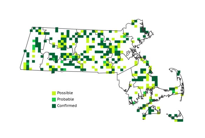
Atlas 1 Distribution
Atlas 1 found Bank Swallows to be widely but irregularly distributed within the Commonwealth. Areas of concentration suggested the availability of riverbanks ideal for burrowing, or else the presence of sand and similar fill left standing in large mounds. On the whole, Bank Swallows showed a greater affiliation with particular localities where nesting conditions were suitable than with any given ecoregion, although the Connecticut River Valley did have Bank Swallows in more than half of all blocks. Occupancy figures in the 30-45% range were the norm across the Worcester Plateau regions and the Coastal Plains, but seemingly very few Bank Swallows could find suitable nesting sites in the Boston Basin, which had only 11% occupancy. The Bristol/Narragansett Lowlands had a slightly more robust distribution (21%), and the swallows were present in more than a third of all Cape and Islands blocks.
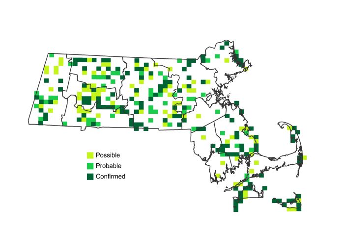
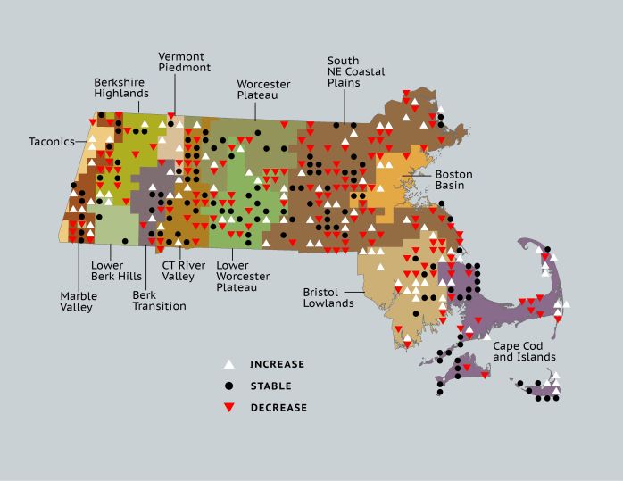
Atlas 2 Distribution and Change
Fresh erosion continues along the seashore, and people continue to disturb the earth and leave it in piles (i.e., development rolls on), so why the Bank Swallow has markedly declined in the state in the last three decades is somewhat of a mystery. The species’ spatial distribution in Atlas 2 remained as broad and irregular as it was during Atlas 1, but nearly one-third fewer Confirmations were recorded. The Connecticut River Valley experienced some of the greatest decreases, losing Bank Swallows in more than 20% of the best-covered blocks (not a good sign for the “river river,” or Riparia riparia, bird), while the Lower Worcester Plateau and Coastal Plains also saw notable drops in occupancy. While the species remained roughly stable in most other regions of the state, it was apparent that Bank Swallows had vacated many of their former haunts in Massachusetts.
Atlas 1 Map
Atlas 2 Map
Atlas Change Map
Ecoregion Data
Atlas 1 | Atlas 2 | Change | ||||||
Ecoregion | # Blocks | % Blocks | % of Range | # Blocks | % Blocks | % of Range | Change in # Blocks | Change in % Blocks |
Taconic Mountains | 1 | 6.3 | 0.3 | 3 | 12.0 | 1.1 | 2 | 13.3 |
Marble Valleys/Housatonic Valley | 19 | 48.7 | 6.2 | 17 | 43.6 | 6.1 | -2 | -5.1 |
Berkshire Highlands | 14 | 25.5 | 4.5 | 10 | 18.2 | 3.6 | -5 | -9.4 |
Lower Berkshire Hills | 4 | 14.3 | 1.3 | 4 | 12.9 | 1.4 | 0 | 0.0 |
Vermont Piedmont | 5 | 29.4 | 1.6 | 7 | 41.2 | 2.5 | 1 | 8.3 |
Berkshire Transition | 10 | 26.3 | 3.2 | 14 | 35.0 | 5.0 | 1 | 3.2 |
Connecticut River Valley | 34 | 60.7 | 11.0 | 28 | 43.1 | 10.0 | -11 | -22.9 |
Worcester Plateau | 24 | 30.8 | 7.8 | 24 | 27.3 | 8.6 | -2 | -4.2 |
Lower Worcester Plateau | 33 | 44.6 | 10.7 | 24 | 30.0 | 8.6 | -10 | -18.5 |
S. New England Coastal Plains and Hills | 90 | 33.3 | 29.2 | 71 | 25.1 | 25.4 | -28 | -12.4 |
Boston Basin | 6 | 10.7 | 1.9 | 5 | 8.9 | 1.8 | -1 | -1.8 |
Bristol and Narragansett Lowlands | 22 | 20.8 | 7.1 | 20 | 17.5 | 7.2 | -2 | -2.0 |
Cape Cod and Islands | 46 | 33.8 | 14.9 | 52 | 36.1 | 18.6 | 0 | 0.0 |
Statewide Total | 308 | 31.8 | 100.0 | 279 | 26.9 | 100.0 | -57 | -6.9 |
Notes
In accordance with Atlas declines, the Bank Swallow shows significant decreasing Breeding Bird Survey trends in Massachusetts and in the Eastern US overall.