


Find a Bird
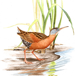
Virginia Rail
Rallus limicola
Somewhat local and strongly increasing
“…you’ll marry a combination of calico and consumption that’s as thin as a rail…” – Mark Twain, Roughing It
Contrary to what some birders say, the old idiom “thin as a rail” refers to a fabricated rod and not to any member of the family Rallidae. However, anyone who has seen a Virginia Rail head-on can easily see how aptly that saying describes the bird. As with most other rails, the bodies of Virginia Rails are laterally compressed, allowing them to slip easily between the cattails and sedges of their marshy habitat. While they are still inconspicuous birds of retiring habits, they are more often seen than most other breeding rails in Massachusetts, and they can be found in many wetlands as long as there is healthy emergent vegetation.
Historic Status
Secretiveness has served the Virginia Rail well over time. William Peabody and the ornithologists of his day, in the 1830s, knew of this bird and some of its habits; and they were able to report it to the state legislators as a breeding species (Peabody 1839). It maintained its ranks well through the Civil War, World War I, and World War II, utilizing the dense wetlands of the state for cover and generally making itself an inconvenient target for hunters, especially when compared with the Sora (Forbush 1927).
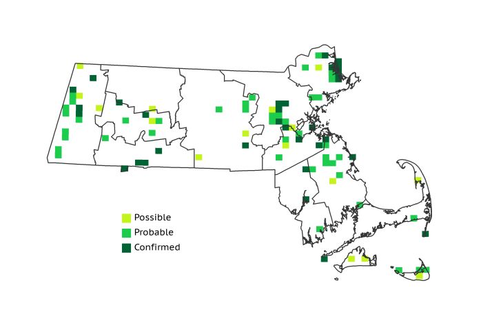
Atlas 1 Distribution
Virginia Rails still haunted the state’s marshes, wet meadows, and weedy ponds during the Atlas 1 survey period. The Marble Valleys had the highest proportion of occupied blocks in the state, with Virginia Rails recorded in more than a quarter of all blocks in that region. A few blocks in the Berkshire Highlands and Berkshire Transition bridged the gap to the more abundant wetland habitat in the Connecticut River Valley, where 9 of the state’s 90 occupied blocks were located. Virginia Rails had a heavier presence in the Coastal Plains and Boston Basin, especially near extensive wetland habitat such as Great Meadows National Wildlife Refuge and the Great Marsh in northern Essex County. The Bristol/Narragansett Lowlands had a cluster of breeding activity in the northeast corner of that region where swampy habitat abounded. Nearly a dozen Cape and Islands Atlas blocks reported Virginia Rails, including Confirmations on the Elizabeth Islands and Monomoy National Wildlife Refuge.
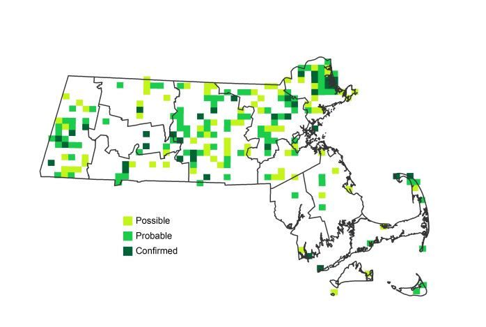
Atlas 2 Distribution and Change
During Atlas 2 Virginia Rails were more widespread than they were in the first Atlas. Although some regions such as the Taconic Mountains and Berkshire Transition had fewer occupied blocks than they did four decades ago, most of the western part of the state reported distribution increases for this unobtrusive, yet opportunistic, rail. This positive trend only increased moving eastward, with the Worcester Plateau and Lower Worcester Plateau regions both experiencing notable Virginia Rail expansion. Block occupancy also rose appreciably in the Coastal Plains, particularly in Essex and northern Middlesex Counties. The Boston Basin and Cape Cod also underwent net growth in Virginia Rail distribution, though there was a slight decline in the Bristol/Narragansett Lowlands. The blocks from which the Virginia Rail disappeared in this region were fairly evenly distributed, suggesting that larger regional factors may be determining factors rather than the loss of specific wetland habitat.
Atlas 1 Map
Atlas 2 Map
Atlas Change Map
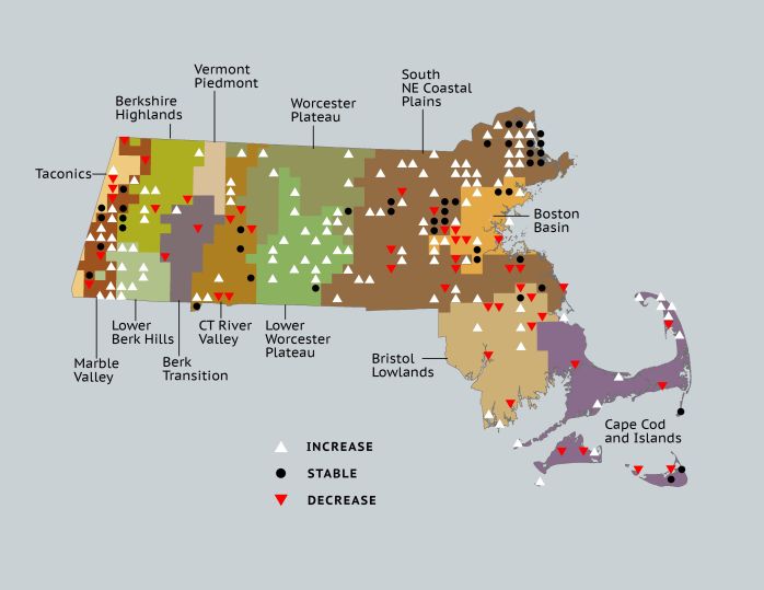
Ecoregion Data
Atlas 1 | Atlas 2 | Change | ||||||
Ecoregion | # Blocks | % Blocks | % of Range | # Blocks | % Blocks | % of Range | Change in # Blocks | Change in % Blocks |
Taconic Mountains | 3 | 18.8 | 3.3 | 2 | 8.0 | 0.9 | -1 | -6.7 |
Marble Valleys/Housatonic Valley | 10 | 25.6 | 11.1 | 17 | 43.6 | 7.9 | 7 | 17.9 |
Berkshire Highlands | 4 | 7.3 | 4.4 | 7 | 12.7 | 3.2 | 3 | 5.7 |
Lower Berkshire Hills | 0 | 0.0 | 0.0 | 8 | 25.8 | 3.7 | 8 | 29.6 |
Vermont Piedmont | 0 | 0.0 | 0.0 | 0 | 0.0 | 0.0 | 0 | 0.0 |
Berkshire Transition | 2 | 5.3 | 2.2 | 1 | 2.5 | 0.5 | -1 | -3.2 |
Connecticut River Valley | 9 | 16.1 | 10.0 | 15 | 23.1 | 6.9 | 1 | 2.1 |
Worcester Plateau | 1 | 1.3 | 1.1 | 19 | 21.6 | 8.8 | 7 | 14.6 |
Lower Worcester Plateau | 1 | 1.4 | 1.1 | 27 | 33.8 | 12.5 | 18 | 33.3 |
S. New England Coastal Plains and Hills | 32 | 11.9 | 35.6 | 86 | 30.4 | 39.8 | 33 | 14.6 |
Boston Basin | 8 | 14.3 | 8.9 | 12 | 21.4 | 5.6 | 4 | 7.3 |
Bristol and Narragansett Lowlands | 9 | 8.5 | 10.0 | 7 | 6.1 | 3.2 | -2 | -2.0 |
Cape Cod and Islands | 11 | 8.1 | 12.2 | 15 | 10.4 | 6.9 | 5 | 4.2 |
Statewide Total | 90 | 9.3 | 100.0 | 216 | 20.8 | 100.0 | 82 | 9.9 |