

Breeding Bird Atlas 2 Ecoregions
Massachusetts falls within two ecoregions, the Northeastern Highlands and the Northeastern Coastal Zone. These can be further divided into 13 subregions. The major forest cover in the Northeastern Highlands habitat sector is northern hardwood (maple-beech-birch) and northern hardwood-spruce. Northeastern spruce-fir forests occur in the areas of highest elevation. Major Massachusetts river systems in the Northeastern Highlands include the Hoosic, Housatonic, Deerfield, Westfield, Farmington, Millers, and small parts of the Connecticut, upper Nashua, and upper Chicopee.
The most extensive ecoregion in Massachusetts—the Northeastern Coastal Zone—is dominated by glacial plains covered with low to high hills that support land uses of woodland and forest, along with some cropland and pasture, and some sizable areas of urbanization (Anderson 1970). The predominant natural forest cover is Appalachian oak forest and northeastern oak-pine forest (Kuchler 1970). Primary drainage basins in the Northeastern Coastal Zone are the Connecticut, Chicopee, Quinebaug, French, Blackstone, Nashua, Concord, Merrimack, Shawsheen, Parker, Ipswich, North Coastal, Boston Harbor, Charles, Ten Mile, Taunton, South Coastal, Narragansett Bay, Mount Hope Bay, Buzzards Bay, Cape Cod Bay, and the Islands.
These two large ecoregions each encompass a wide geographic area in the Commonwealth and are too coarse a lens to have much relevance to bird conservation. The 13 subregions, however, are much more specific and in many cases directly inform the distribution of breeding birds around the state. For this reason, the 13 subregions are a focus of our analyses of changing bird distributions, and are referred to as “ecoregions” in much of the document. A brief description of each of these 13 regions follows below.
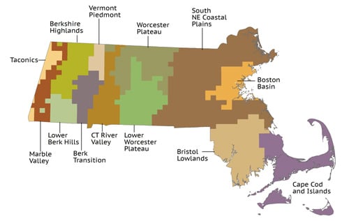
Northeastern Highlands Subregions
Taconic Mountains – This subregion, dominated by Mount Greylock (3,491 feet), the highest point in the Commonwealth, is the primary breeding station for the Blackpoll Warbler, Mourning Warbler, and Bicknell’s Thrush (historically) in the state. The forest is mainly northern hardwood (maple-beech-birch) with some spruce and fir remaining at higher elevations.
Western New England Marble Valleys (i.e., Berkshire Valley and Stockbridge Valley in Massachusetts) – This scenic region is characterized by a number of suburban and semiurban communities, cropland and pastures, and both transition (oak-hickory) and northern hardwood forests, depending upon the latitude and elevation. The Black Vulture and Cliff Swallow are two specialty species of this subregion in Massachusetts.
Green Mountains/Berkshire Highlands – This subregion is relatively high (for Massachusetts), with elevations ranging from 1,000 to more than 2,500 feet, and is cloaked with spruce-fir and northern hardwood forest types. This area – often referred to as the Berkshire Highlands – is the distribution center for species like the Swainson’s Thrush.
Lower Berkshire Hills – This region is similar to the Berkshire Highlands to the north, but the average elevation is lower, (1,000 to 1,700 feet) with a forest cover composed primarily of northern hardwoods and lacking the high-elevation spruce-fir; it also contains an element of the more southern transition hardwood (oak-hickory) forest. No breeding species are unique to this subregion.
Berkshire Transition – This region is not unlike the Lower Berkshire Hills, except that its average elevation is lower (400 to 1,400 feet) and it possesses primarily transition hardwood forest, with patches of northern hardwoods at higher elevations. No breeding species are unique to this subregion.
Vermont Piedmont – This subregion is characterized by hills, some having steep slopes and elevations ranging from 400 to 1,400 feet in Massachusetts. The forest cover resembles that of the Berkshire Transition subregion, the primary differences being soil types. No breeding species are unique to this subregion, although, not unlike the Berkshire Highlands to the west, a number of breeding species with northern affinities (e.g., the Yellow-bellied Sapsucker, Black-throated Blue Warbler, and Yellow-rumped Warbler) are notably more numerous as breeders in this region than in other regions of the state. The Montague Sandplains also fall in this region, hosting notable concentrations of birds like the Prairie Warbler.
Worcester/Monadnock Plateau – This is a large and important subregion that includes most of the mountainous and hilly areas of the central uplands of Massachusetts. Elevations range from 500 to 1,400 feet, with the exception of Mount Watatic (1,832 feet) and Mount Wachusett (2,006 feet), both of which provide easterly outposts for northern breeding species more typical of the higher elevations of western Massachusetts (e.g., the Yellow-bellied Sapsucker, Olive-sided Flycatcher [rare], Golden-crowned Kinglet, Dark-eyed Junco). The presence of Quabbin Reservoir accounts for birds such as the Common Loon and Cerulean Warbler. Forest types are largely transition and northern hardwoods, with pockets of spruce on the higher hilltops.
Northeastern Coastal Zone Subregions
Connecticut River Valley – A clearly discernible subregion, the Connecticut Valley has a milder climate than the adjacent hill country; relatively level terrain, ranging from 100 to 500 feet on the highest ridges; and land composed mostly of urban and built-up areas, croplands, and pasture. Deciduous forests of central hardwoods (oak-hickory) and transition hardwoods (maple-beech-birch, oak-hickory) cover most of the ridges. Breeding birds that showed a correlation with this subregion during the Atlas period included grassland species such as the Grasshopper Sparrow and Vesper Sparrow, particularly when compared with the hill subregions to the east and west. The extensive river systems throughout the region also made it a haven for our national bird, the Bald Eagle. The combined effects of milder temperatures, lower elevation, and an overall more southerly forest type in this subregion were quite likely among the factors making it a key colonization inroad for species expanding into Massachusetts from the south.
Lower Worcester Plateau/Eastern Connecticut Upland – This region and the Southern New England Coastal Plains and Hills subregion are in many respects quite similar. In this sector, elevation ranges from 300 to 500 feet, and the landscape is described as open hills where 50 to 75 percent of the gentle slope is on the upland (Hammond 1970). The forest cover is mainly a mixture of transition and central hardwoods (oak-hickory), as well as some elm-ash-Red Maple and White Pine-Red Pine. There are no breeding bird species specifically associated with this subregion, although the inclusion of the Quabbin area made this region (like the Worcester Pleateau) an important one for the Cerulean Warbler.
Southern New England Coastal Plains and Hills – This is the largest subregion in Massachusetts and is perhaps the most diverse in its characteristics and habitats. Elevation ranges from sea level to 800 feet, with Great Blue Hill representing the highest point in eastern Massachusetts. The principal forest types are central hardwoods, along with transition hardwoods on the richer soils, White Pine-Red Pine, and elm-ash-Red Maple, particularly in southeastern Massachusetts. This region contains a wide representation of the bird species regularly found nesting in Massachusetts. The presence of Great Meadows National Wildlife Refuge and Parker River National Wildlife Refuge make the Coastal Plains a particular haven for marsh species such as the Blue-winged Teal, Marsh Wren, and Swamp Sparrow.
Boston Basin – A heavily developed subregion, the Boston Basin contains a number of ponds, lakes, and reservoirs and is drained primarily by the Neponset, Charles, Mystic, and Saugus rivers. The topography is low and rolling, studded with drumlins and glacial till-covered bedrock hills. Forests are mainly transition hardwoods (oak-hickory), often heavily mixed with White Pine. Few bird species are specifically associated with this subregion; nearly every block surveyed in this sector during the Atlas period Confirmed the nesting of those widespread species routinely associated with suburbia. Interesting exceptions are many colonially nesting wading birds and seabirds, which favor the rocky offshore islands of this ecoregion; city-adapted species like the Peregrine Falcon are also well represented, including one species that breeds nowhere else in the state – the Monk Parakeet.
Bristol/Narragansett Lowland – This subregion is characterized by flat to gently rolling irregular plains with elevations generally lower than 200 feet. Land cover is mostly mixed forest with numerous wetlands, including lakes and ponds, and small areas of cropland and pastures. Cranberry bogs are notably abundant. The forest type is mainly central hardwood, with a liberal presence of elm-ash-Red Maple and White Pine-Red Pine (Kingsley 1974). Breeding birds showing an affinity for this subregion include the White-eyed Vireo and the Purple Martin.
Cape Cod/Long Island – One of the most distinctive subregions, this area is defined by its low elevation (generally below 200 feet) and prominent glacial features such as terminal moraines, outwash plains, kettle ponds, and coastal sand dunes. The most abundant forest cover is oak-Pitch Pine, and there are a number of distinctive aquatic habitats including salt- and freshwater marshes, swamps, and bogs. Characteristic breeding birds of this subregion are many, including some species that Massachusetts accounts for a significant portion of the national (or world!) population – the Piping Plover, Roseate Tern, and Saltmarsh Sparrow for example.
Stay Connected
Don’t miss a beat on all the ways you can get outdoors, celebrate nature, and get involved.