

Find a Bird
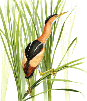
Least Bittern
Ixobrychus exilis
Local and likely increasing
Action/monitoring needed
Endangered Species
“We need the tonic of wildness—to wade sometimes in marshes where the bittern and the meadow-hen lurk” – Henry David Thoreau, Walden
If the American Bittern is inconspicuous, then the Least Bittern seems practically invisible. Diminutive and secretive, this skulking member of the heron clan creeps and clambers through the fresh and brackish cattail marshes of Massachusetts. It has never been abundant, or if so has been so easily overlooked as to create the illusion of scarcity. For all their supposed elusiveness, where Least Bitterns are found nesting, they are often found in surprising abundance. Once, it was not unheard of for a dozen nests to exist within a single hectare of suitable habitat. Such nests are formed of cattails, bulrushes, and other emergent vegetation bent over and crimped into a flat platform upon which the eggs are laid, often with an overhead canopy for additional security.
Historic Status
Its secretiveness has led to a long history of having little written about it in Massachusetts, yet the species has been recognized as a nesting species in the state for more than a century and a half. The best that chroniclers have been able to say is ably summed up in the mid-1920s by Edward Howe Forbush: “Probably the Least Bittern is not so rare in the marshy regions of New England as the published lists would seem to indicate... Probably we know very little about its real distribution in New England in the breeding season” (Forbush 1925). The one thing that we do know is that during the twentieth century, those “marshy regions” were drained extensively, undoubtedly causing the Least Bittern to lose a lot of its preferred habitat by the time of Atlas 1.
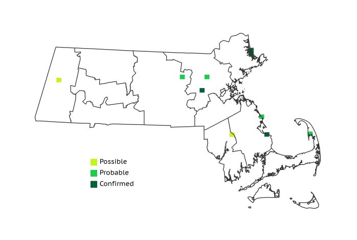
Atlas 1 Distribution
Ever elusive, Least Bitterns were recorded sporadically across the landscape in Atlas 1. The Marble Valleys had a single Possible block, and the next most western record was in the Coastal Plains. The Coastal Plains had 6 blocks in all, more than all other regions combined, but these blocks were scattered throughout the region with the exception of a pair of Confirmed blocks at Parker River National Wildlife Refuge. Only 3 other blocks – 1 in the Bristol/Narragansett Lowlands and 2 on Cape Cod – contained the sort of extensive cattail marshes necessary to shelter breeding Least Bitterns.
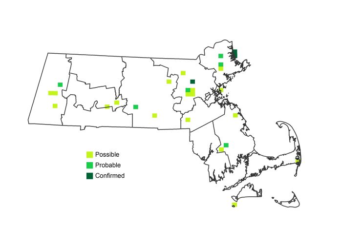
Atlas 2 Distribution and Change
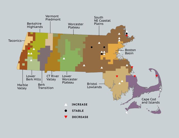
While hardly sustaining a population explosion, Least Bitterns more than doubled their footprint in Massachusetts between Atlas 1 and Atlas 2, going from 1% coverage of the state to 2.6%. Notable gains were made at opposite ends of the Bay State, in the Coastal Plains and the Berkshire Highlands, with scattered records coming in from other parts of Massachusetts, including lower Cape Cod, Nomans Island, and the Bristol/Narragansett Lowlands. Plum Island’s breeding population marched steadily forward. While apparently well established, the state-endangered Least Bittern would benefit from close monitoring in the coming years to ensure that any declines in this small population are detected before the drop becomes dire.
Atlas 1 Map
Atlas 2 Map
Atlas Change Map
Ecoregion Data
Atlas 1 | Atlas 2 | Change | ||||||
Ecoregion | # Blocks | % Blocks | % of Range | # Blocks | % Blocks | % of Range | Change in # Blocks | Change in % Blocks |
Taconic Mountains | 0 | 0.0 | 0.0 | 0 | 0.0 | 0.0 | 0 | 0.0 |
Marble Valleys/Housatonic Valley | 1 | 2.6 | 10.0 | 0 | 0.0 | 0.0 | -1 | -2.6 |
Berkshire Highlands | 0 | 0.0 | 0.0 | 3 | 5.5 | 11.1 | 3 | 5.7 |
Lower Berkshire Hills | 0 | 0.0 | 0.0 | 1 | 3.2 | 3.7 | 1 | 3.7 |
Vermont Piedmont | 0 | 0.0 | 0.0 | 0 | 0.0 | 0.0 | 0 | 0.0 |
Berkshire Transition | 0 | 0.0 | 0.0 | 0 | 0.0 | 0.0 | 0 | 0.0 |
Connecticut River Valley | 0 | 0.0 | 0.0 | 0 | 0.0 | 0.0 | 0 | 0.0 |
Worcester Plateau | 0 | 0.0 | 0.0 | 0 | 0.0 | 0.0 | 0 | 0.0 |
Lower Worcester Plateau | 0 | 0.0 | 0.0 | 3 | 3.8 | 11.1 | 1 | 1.9 |
S. New England Coastal Plains and Hills | 6 | 2.2 | 60.0 | 15 | 5.3 | 55.6 | 9 | 4.0 |
Boston Basin | 0 | 0.0 | 0.0 | 1 | 1.8 | 3.7 | 1 | 1.8 |
Bristol and Narragansett Lowlands | 1 | 0.9 | 10.0 | 2 | 1.8 | 7.4 | 1 | 1.0 |
Cape Cod and Islands | 2 | 1.5 | 20.0 | 2 | 1.4 | 7.4 | 0 | 0.0 |
Statewide Total | 10 | 1.0 | 100.0 | 27 | 2.6 | 100.0 | 15 | 1.8 |