

Find a Bird
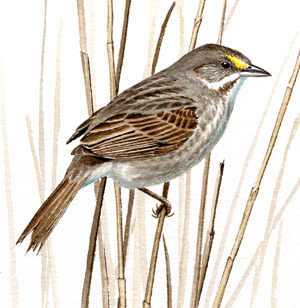
Seaside Sparrow
Ammodramus maritimus
Very local and likely declining
Action/monitoring needed
State Wildlife Action Plan listed
“My life is like a stroll on the beach…as near to the edge as I can go.” – Henry David Thoreau, The Fisher’s Boy
At the interface between land and sea dwells the Seaside Sparrow, a bird whose existence is defined by its precarious position on the water’s edge. The Seaside Sparrow is stocky and darkly feathered, with a long bill that sets it apart from other sparrows. Amidst cordgrass and saltgrass it lurks, doing its best to avoid the predators above and the rising waters below. The beleaguered Seaside Sparrows of the Bay State have a mighty challenge ahead of them as climate change threatens to wreak major changes on their salt marsh homes. Only time will tell if Seaside Sparrows can weather the coming storm, but for the time being they are holding their course.
Historic Status
The 1839 report to the state legislature of the birds of Massachusetts states matter-of-factly that the “seaside finch is found along the borders of the ocean, and in the sea islands” (Peabody 1839), but within a few decades the species was considered rare. “Said to occur commonly along the coast of our State,” wrote Charles Johnson Maynard just three decades later, “which statement I doubt, as I have searched carefully for it from the mouth of the Merrimac River to the extreme south shore, and have yet to meet with a single living specimen” (Maynard 1870). Single sightings became noteworthy, like the young male found in Nahant in 1877 (Howe & Allen 1901). A nest at Westport caused raised eyebrows in 1896, but such occurrences became commonplace at that locality over the next three decades (Forbush 1929). For most of the twentieth century, the Seaside Sparrow remained an extremely local breeder, even as it expanded its range limits northward into extreme southern Maine.
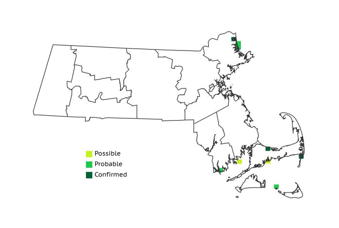
Atlas 1 Distribution
True to form, Seaside Sparrows were found breeding only in areas of grassy salt marsh along the coast in Atlas 1. Parker River National Wildlife Refuge in the northeastern corner of the Coastal Plains was a major locale for Seaside Sparrow breeding activity. Areas along the western shore of Buzzards Bay in the Bristol/Narragansett Lowlands also had some suggestion of breeding, and the birds were Confirmed at 2 sites in the Cape and Islands: at north Monomoy Island, and in the salt marshes near the base of Sandy Neck in Barnstable. Muskeget Island also hosted Probable Seaside Sparrows, but the species nonetheless remained very local in its breeding distribution by the time Atlas 1 was completed.
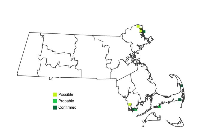
Atlas 2 Distribution and Change
When Atlas 2 fieldwork concluded, the story was one of stasis for Seaside Sparrow: 6 new nesting blocks, 6 lost, 3 historic blocks held. It was not the past or the present distribution of the bird that caught the attention of many Atlas workers, however. Rather it was the concern over the threat of future sea-level rise and how it could possibly threaten the existence of this species in Massachusetts. Protection of appropriate coastal salt marsh habitat in the future will be essential to sustaining the remaining Seaside Sparrows in the Bay State.
Atlas 1 Map
Atlas 2 Map
Atlas Change Map
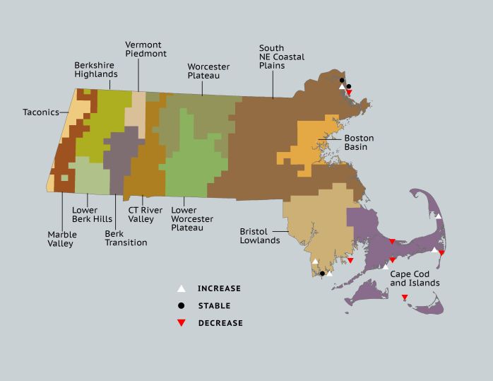
Ecoregion Data
Atlas 1 | Atlas 2 | Change | ||||||
Ecoregion | # Blocks | % Blocks | % of Range | # Blocks | % Blocks | % of Range | Change in # Blocks | Change in % Blocks |
Taconic Mountains | 0 | 0.0 | 0.0 | 0 | 0.0 | 0.0 | 0 | 0.0 |
Marble Valleys/Housatonic Valley | 0 | 0.0 | 0.0 | 0 | 0.0 | 0.0 | 0 | 0.0 |
Berkshire Highlands | 0 | 0.0 | 0.0 | 0 | 0.0 | 0.0 | 0 | 0.0 |
Lower Berkshire Hills | 0 | 0.0 | 0.0 | 0 | 0.0 | 0.0 | 0 | 0.0 |
Vermont Piedmont | 0 | 0.0 | 0.0 | 0 | 0.0 | 0.0 | 0 | 0.0 |
Berkshire Transition | 0 | 0.0 | 0.0 | 0 | 0.0 | 0.0 | 0 | 0.0 |
Connecticut River Valley | 0 | 0.0 | 0.0 | 0 | 0.0 | 0.0 | 0 | 0.0 |
Worcester Plateau | 0 | 0.0 | 0.0 | 0 | 0.0 | 0.0 | 0 | 0.0 |
Lower Worcester Plateau | 0 | 0.0 | 0.0 | 0 | 0.0 | 0.0 | 0 | 0.0 |
S. New England Coastal Plains and Hills | 3 | 1.1 | 33.3 | 4 | 1.4 | 40.0 | 0 | 0.0 |
Boston Basin | 0 | 0.0 | 0.0 | 0 | 0.0 | 0.0 | 0 | 0.0 |
Bristol and Narragansett Lowlands | 2 | 1.9 | 22.2 | 3 | 2.6 | 30.0 | 1 | 1.0 |
Cape Cod and Islands | 4 | 2.9 | 44.4 | 3 | 2.1 | 30.0 | -1 | -0.8 |
Statewide Total | 9 | 0.9 | 100.0 | 10 | 1.0 | 100.0 | 0 | 0.0 |