

Find a Bird
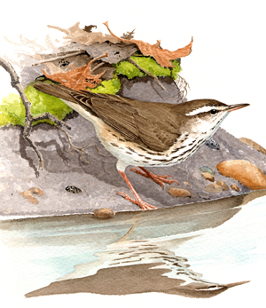
Louisiana Waterthrush
Parkesia motacilla
Somewhat local and strongly increasing
State Wildlife Action Plan listed
“…one of the birds rises high up in the air above its pursuer, and then flutters slowly downward, pouring out its sweet song as it descends, mingling its cadence with the sound of the brook – the whole effect in perfect harmony with the spirit of the place.” – Dr. Mearns, in Arthur Cleveland Bent, Life Histories of North American Wood Warblers
This Dixie cousin of the Northern Waterthrush overlaps with the range of the Northern Waterthrush in southern New England. Where both Louisiana and Northern Waterthrushes occur, they each have their preferred feeding and nesting habitats. Northern Waterthrushes forage along the shores of sluggish rivers and standing pools of water, while Louisiana Waterthrushes chase the current of fast-flowing creeks and babbling brooks. Several Louisiana Waterthrush pairs may occupy adjacent territories along the same stream, but each pair vigorously defends its own stretch of the steam. Despite their similarities, the two waterthrush species have never been known to hybridize (Eaton 1995).
Historic Status
One of the earliest records for Massachusetts of the Large-billed Water Wagtail, as it was long ago known, was made on April 28, 1869, on Mount Tom in Holyoke, when a single member of the species was collected there. The first nesting record consisted of a pair feeding a fledgling in Sheffield on June 11, 1896 (Howe & Allen 1901). For the next three decades the bird continued to be a rare visitor and summer resident in the western half of the state. Prior to 1930, the Louisiana Waterthrush had not significantly colonized eastern Massachusetts (Forbush 1929). That eastward movement may have been triggered by the reforestation of areas previously cut clear during the state’s agricultural heyday.
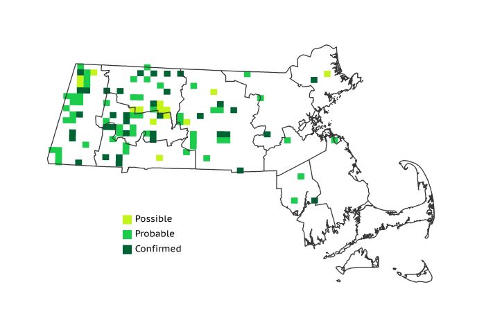
Atlas 1 Distribution
True to its name, the Louisiana Waterthrush breeds right at the water’s edge, often along a brook or stream in the heart of a forest. Statewide they were found in 11% of the blocks surveyed during Atlas 1, with 60% of the occupied blocks located from the Connecticut River Valley westward. The western distribution fell mostly along the eastern slope of the Taconics, following the running waters down into the Marble Valleys. The Louisiana Waterthrush bears the distinction of being one of the few species breeding in Massachusetts that particularly favors the Berkshire Transition region; they occupied almost twice as many blocks there as in the larger neighboring Connecticut River Valley. They were uncommonly encountered across the Worcester Plateau regions, and were seldom seen farther east. Even so, local breeding was Confirmed as far east as the Bristol/Narragansett Lowlands ecoregion.
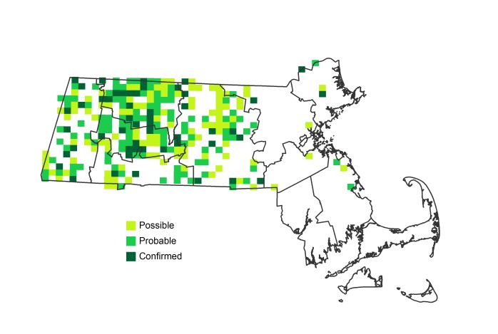
Atlas 2 Distribution and Change
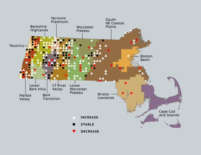
By the time of Atlas 2, the ringing song of the Louisiana Waterthrush cascaded through 26% of the blocks surveyed in Massachusetts. They posted gains in nearly every region, ranging from modest fluctuations in the Marble Valleys to the remarkable establishment of breeding in nearly half of all Berkshire Highlands blocks. All the way to the Worcester Plateau regions, Louisiana Waterthrushes were consistently expanding their distribution and consolidating their coverage. The easternmost pioneers of the species, however, seemed to be proceeding more slowly. Atlas 2 welcomed Louisiana Waterthrushes to the Boston Basin with a single occupied block north of the city, but at the same time the bird gave up its tenuous foothold in the Bristol/Narragansett Lowlands.
Atlas 1 Map
Atlas 2 Map
Atlas Change Map
Ecoregion Data
Atlas 1 | Atlas 2 | Change | ||||||
Ecoregion | # Blocks | % Blocks | % of Range | # Blocks | % Blocks | % of Range | Change in # Blocks | Change in % Blocks |
Taconic Mountains | 9 | 56.3 | 8.6 | 12 | 48.0 | 4.5 | 1 | 6.7 |
Marble Valleys/Housatonic Valley | 15 | 38.5 | 14.3 | 17 | 43.6 | 6.4 | 2 | 5.1 |
Berkshire Highlands | 5 | 9.1 | 4.8 | 28 | 50.9 | 10.5 | 22 | 41.5 |
Lower Berkshire Hills | 4 | 14.3 | 3.8 | 8 | 25.8 | 3.0 | 4 | 14.8 |
Vermont Piedmont | 5 | 29.4 | 4.8 | 16 | 94.1 | 6.0 | 7 | 58.3 |
Berkshire Transition | 16 | 42.1 | 15.2 | 27 | 67.5 | 10.2 | 7 | 22.6 |
Connecticut River Valley | 9 | 16.1 | 8.6 | 32 | 49.2 | 12.0 | 16 | 33.3 |
Worcester Plateau | 16 | 20.5 | 15.2 | 50 | 56.8 | 18.8 | 14 | 29.2 |
Lower Worcester Plateau | 11 | 14.9 | 10.5 | 34 | 42.5 | 12.8 | 15 | 27.8 |
S. New England Coastal Plains and Hills | 12 | 4.4 | 11.4 | 41 | 14.5 | 15.4 | 19 | 8.4 |
Boston Basin | 0 | 0.0 | 0.0 | 1 | 1.8 | 0.4 | 1 | 1.8 |
Bristol and Narragansett Lowlands | 3 | 2.8 | 2.9 | 0 | 0.0 | 0.0 | -3 | -3.0 |
Cape Cod and Islands | 0 | 0.0 | 0.0 | 0 | 0.0 | 0.0 | 0 | 0.0 |
Statewide Total | 105 | 10.8 | 100.0 | 266 | 25.7 | 100.0 | 105 | 12.7 |