

Find a Bird
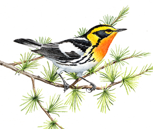
Blackburnian Warbler
Dendroica fusca
Somewhat local and likely increasing
“…one must never let the fire go out in one’s soul, but keep it burning.” – Vincent van Gogh
The fiery throat, face, and breast of the breeding Blackburnian Warbler set it apart from its fellows. A boreal forest warbler, the Blackburnian breeds south of Massachusetts mainly in the Appalachian Mountains. Most of the species’ breeding range lies in northern New England and eastern Canada. Although Blackburnian Warblers require fairly substantial areas of intact mature forest, they will tolerate some “edge” in that habitat, and have managed to keep their fires burning brightly throughout the past few centuries in Massachusetts.
Historic Status
The story of the Blackburnian Warbler in Massachusetts had not been fully divined by ornithologists in the early part of the nineteenth century. In his report to the state legislature, William Peabody could say nothing more than, “In the list furnished me by Dr. Brewer, it is marked as breeding in this state,” (Peabody 1839). As with the Mourning Warbler, it would take some mountain climbing to find out about this species’ penchant for coniferous forests at high elevations. “The whispering forest is its home,” Forbush would say later (Forbush 1929). J.A. Farley did note, however, finding a nest in Lynnfield in 1901, among the hemlock forests of that area, and that region soon became a secondary home for the Blackburnian Warbler in Massachusetts (Farley 1901).
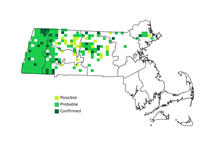
Atlas 1 Distribution
A resident of the high places in the Commonwealth, the Blackburnian Warbler was still decidedly western in distribution during Atlas 1, breeding in 26% of the state, and its distribution mimics several other breeding wood warblers. It would actually be easier to call out the blocks in which Blackburnian Warblers did not occur for the Taconic Mountains, Marble Valleys, Berkshire Highlands, and Lower Berkshire Hills, where they consolidated 53% of their statewide range. The Berkshire Transition region lived up to its name as Blackburnian Warblers transitioned from ubiquitous in the west to fairly widespread in the eastern part of that region. Only 7 Connecticut River Valley blocks had signs of breeding Blackburnian Warblers, but the higher Worcester Plateau recorded the species in 39 blocks, mirroring the tail-like reach in distribution seen in several other higher altitude breeders, and reminding us that this region is closer in habitat characteristics to the western ecoregions than the eastern ecoregions. Small clusters of breeding activity were also recorded in the Lower Worcester Plateau and the Coastal Plains, but this accounted for only about 15% of their statewide breeding footprint.
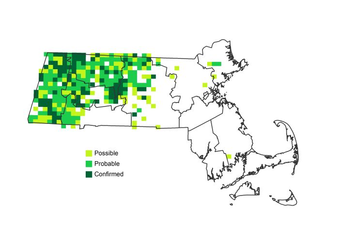
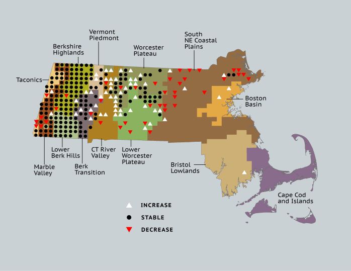
Atlas 2 Distribution and Change
No matter how often it happens, glimpsing a Blackburnian Warbler flitting though the hemlocks, its orange-yellow throat ablaze, is breathtaking. During Atlas 2, volunteers were treated to an overall increase in this spectacular species’ footprint, with 31% block occupancy. The species’ persistence in the western highland regions was stable in Atlas 2, with only a few blocks newly vacated or newly occupied west of the Connecticut River Valley. As with many western warbler species, the Connecticut Valley itself saw an increase in occupancy for this species, especially in the northern part of the region. In the Worcester Plateau regions Blackburnian Warblers continued the steady increase corroborated by the Breeding Bird Survey, but it was a different story in the eastern part of the state. They appeared to be in full retreat from the Coastal Plains, possibly reflecting the die-off of many mature Eastern Hemlocks due to adelgid incursions. Although birds were still seen in summer at several locations in eastern Massachusetts, no breeding was Confirmed east of the Worcester Plateau.
Atlas 1 Map
Atlas 2 Map
Atlas Change Map
Ecoregion Data
Atlas 1 | Atlas 2 | Change | ||||||
Ecoregion | # Blocks | % Blocks | % of Range | # Blocks | % Blocks | % of Range | Change in # Blocks | Change in % Blocks |
Taconic Mountains | 13 | 81.3 | 5.2 | 14 | 56.0 | 4.4 | -2 | -13.3 |
Marble Valleys/Housatonic Valley | 37 | 94.9 | 14.9 | 35 | 89.7 | 11.1 | -2 | -5.1 |
Berkshire Highlands | 53 | 96.4 | 21.4 | 53 | 96.4 | 16.8 | -1 | -1.9 |
Lower Berkshire Hills | 28 | 100.0 | 11.3 | 29 | 93.5 | 9.2 | 0 | 0.0 |
Vermont Piedmont | 7 | 41.2 | 2.8 | 14 | 82.4 | 4.4 | 3 | 25.0 |
Berkshire Transition | 23 | 60.5 | 9.3 | 35 | 87.5 | 11.1 | 5 | 16.1 |
Connecticut River Valley | 7 | 12.5 | 2.8 | 21 | 32.3 | 6.6 | 9 | 18.8 |
Worcester Plateau | 39 | 50.0 | 15.7 | 71 | 80.7 | 22.5 | 11 | 22.9 |
Lower Worcester Plateau | 19 | 25.7 | 7.7 | 31 | 38.8 | 9.8 | 4 | 7.4 |
S. New England Coastal Plains and Hills | 22 | 8.1 | 8.9 | 10 | 3.5 | 3.2 | -16 | -7.1 |
Boston Basin | 0 | 0.0 | 0.0 | 2 | 3.6 | 0.6 | 2 | 3.6 |
Bristol and Narragansett Lowlands | 0 | 0.0 | 0.0 | 1 | 0.9 | 0.3 | 1 | 1.0 |
Cape Cod and Islands | 0 | 0.0 | 0.0 | 0 | 0.0 | 0.0 | 0 | 0.0 |
Statewide Total | 248 | 25.6 | 100.0 | 316 | 30.5 | 100.0 | 14 | 1.7 |