

Find a Bird
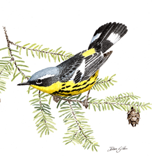
Magnolia Warbler
Dendroica magnolia
Local and likely increasing
“They are a gay lot of bachelors, though, are they not? chasing one another through the branches, more in sport than anger apparently, and uttering their queer, emphatic little songs on all sides.” —William Brewster, Bulletin of the Nuttall Ornithological Club
The striking and distinctive Magnolia Warbler is an iconic breeding species of young coniferous woods. Indeed, this species breeds almost exclusively in boreal conifer forests dominated by spruce, fir, hemlock, and cedar. This might prompt one to wonder why the bird is named for a distinctively southern plant family. Alexander Wilson, the man responsible for many common names of North American birds, is the person behind this name. Magnolia Warbler is so called because this conifer-loving species was christened after Wilson first collected a migrant individual in a magnolia tree in Mississippi in 1810 (Bent 1953).
Historic Status
Massachusetts’ earliest chroniclers of avian life in the state knew the Magnolia Warbler as the Spotted Warbler and as a migrant that passed “but a few days with us and on their return do not visit us” (Peabody 1839). At that time, though, the birds of western Massachusetts were less well known than the birds of the eastern part of the state, and eventually the Black-and-Yellow Warbler – its second name – was found breeding in western Massachusetts. At the start of the twentieth century, Reginald Heber Howe and Glover Morrill Allen recorded breeding sites in the Berkshires and Winchendon, and “presumably at Blandford and Chester in Hampden County,” (Howe & Allen 1901), a pattern similarly described by Edward Howe Forbush (Forbush 1929). As Massachusetts’ higher elevations became reforested, and better studied, this species became more prevalent and more well known.
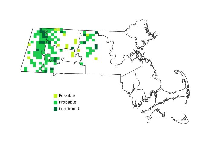
Atlas 1 Distribution
As a denizen of conifers and cool, shaded hemlock ravines, the Magnolia Warbler was most widespread during Atlas 1 in the high western regions, especially the Berkshire Highlands, but it was widely distributed in the Berkshire Transition zone as well. Tallying a statewide block occupancy of 13%, it was only well distributed east of there in the Worcester Plateau, which boasted 17% of the species’ statewide range. The Lower Worcester Plateau had a only a few occupied blocks, but the Atlas 1 breeding distribution of the Magnolia Warbler stopped abruptly at the border between the Worcester Plateau and the Coastal Plains, despite sporadic historical records of the species in eastern Massachusetts.
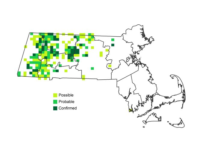
Atlas 2 Distribution and Change
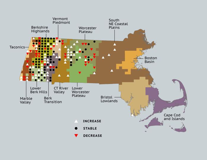
While many warblers feed high in the treetops, the Magnolia Warbler can often be found gleaning insects and spiders in the forest understory, fanning its white-banded tail all the while. As more conifer-dominated woodlands reached maturity, Magnolia Warblers underwent a small but noticeable eastward expansion in Atlas 2, increasing from 13% total block occupancy in Atlas 1 to 19% in Atlas 2. In the western highlands, the species showed increased block occupancy in many of the mid-elevation regions, such as the Lower Berkshire Hills and Berkshire Transition, though occupancy in the Berkshire Highlands and Worcester Plateau was markedly unstable. Magnolia Warblers were not only present but also Confirmed as breeders in the Coastal Plains into Middlesex County. A lone block in the southeast corner of the Bristol/Narragansett Lowlands probably did not represent a genuine breeding attempt, but rather a lingering migrant.
Atlas 1 Map
Atlas 2 Map
Atlas Change Map
Ecoregion Data
Atlas 1 | Atlas 2 | Change | ||||||
Ecoregion | # Blocks | % Blocks | % of Range | # Blocks | % Blocks | % of Range | Change in # Blocks | Change in % Blocks |
Taconic Mountains | 5 | 31.3 | 3.9 | 6 | 24.0 | 3.1 | 1 | 6.7 |
Marble Valleys/Housatonic Valley | 11 | 28.2 | 8.5 | 10 | 25.6 | 5.1 | -1 | -2.6 |
Berkshire Highlands | 42 | 76.4 | 32.6 | 44 | 80.0 | 22.6 | 0 | 0.0 |
Lower Berkshire Hills | 12 | 42.9 | 9.3 | 22 | 71.0 | 11.3 | 9 | 33.3 |
Vermont Piedmont | 6 | 35.3 | 4.7 | 11 | 64.7 | 5.6 | 2 | 16.7 |
Berkshire Transition | 19 | 50.0 | 14.7 | 30 | 75.0 | 15.4 | 7 | 22.6 |
Connecticut River Valley | 3 | 5.4 | 2.3 | 10 | 15.4 | 5.1 | 3 | 6.3 |
Worcester Plateau | 22 | 28.2 | 17.1 | 39 | 44.3 | 20.0 | 2 | 4.2 |
Lower Worcester Plateau | 9 | 12.2 | 7.0 | 15 | 18.8 | 7.7 | -2 | -3.7 |
S. New England Coastal Plains and Hills | 0 | 0.0 | 0.0 | 7 | 2.5 | 3.6 | 6 | 2.7 |
Boston Basin | 0 | 0.0 | 0.0 | 0 | 0.0 | 0.0 | 0 | 0.0 |
Bristol and Narragansett Lowlands | 0 | 0.0 | 0.0 | 1 | 0.9 | 0.5 | 1 | 1.0 |
Cape Cod and Islands | 0 | 0.0 | 0.0 | 0 | 0.0 | 0.0 | 0 | 0.0 |
Statewide Total | 129 | 13.3 | 100.0 | 195 | 18.8 | 100.0 | 28 | 3.4 |