


Find a Bird
Northern Rough-winged Swallow
Stelgidopteryx serripennis

Fairly widespread and likely increasing
“One swallow does not a summer make.” – Aristotle
Despite its drab plumage and relatively quiet personality, the Northern Rough-winged Swallow is as interesting a bird as any of its showier relatives. It often nests in burrows dug in vertical riverbanks, often in the company of Bank Swallows, but will also use human-made structures such as drain pipes, culvert openings, and the like. The eponymous rough bristles on the ninth primary, while not useful as field marks, are nonetheless perceptible in the hand. While most people will never get that near to a Northern Rough-winged Swallow, the species’ nesting habits are bringing it into closer contact with humanity than ever before.
Historic Status
John James Audubon discovered the Northern Rough-winged Swallow in Louisiana in 1819, noting its confounding resemblances to the Bank Swallow but also observing its differences (Audubon 1840). The species underwent a dramatic northward expansion of its breeding range throughout the nineteenth century, initially appearing as a single specimen in Massachusetts in May 1851 in Easthampton (Howe & Allen 1901). The first Possible recorded breeding pair was found in the early 1890s by Walter Faxon in North Adams, but he was unable to confirm nesting until 1895 (Faxon & Hoffman 1900). As birders became more accustomed to identifying this species, sightings increased. By the 1940s, Rough-winged Swallows inhabited the breadth of the Commonwealth and had begun to colonize New Hampshire and Vermont (Petersen & Meservey 2003).
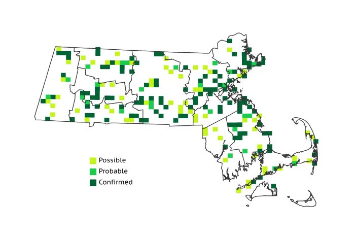
Atlas 1 Distribution
The Atlas 1 distribution of Northern Rough-winged Swallows was remarkably uniform; the birds were present but fairly local in all areas of the state save for the highest regions. While absent from the Taconics, swallows were found in 36% of Marble Valleys blocks. The Berkshire Transition also topped 30% occupancy, and the Connecticut River Valley reported rough-wings in almost a quarter of the region. The Lower Worcester Plateau had more than twice the occupancy figures of its northern sister region, where Northern Rough-winged Swallows were quite local. Just over a quarter of all occupied blocks in the state came from the Coastal Plains, but considering the region’s size this is not particularly outstanding. Rough-wings managed an impressive 36% occupancy in the urbanized Boston Basin, perhaps taking advantage of disused drainpipes as nesting areas, and were present in lesser proportions in the Bristol/Narragansett Lowlands and the Cape and Islands.
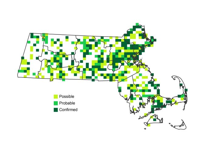
Atlas 2 Distribution and Change
For a species that a century and a half in the past hadn’t even been discovered and named, the Northern Rough-winged Swallow was doing pretty well for itself in Massachusetts by the time of the Atlas 2 period. There wasn't a single ecoregion in the state that did not have at least one new nesting record. The growth was so spectacular that the species’ distribution actually doubled across the state. The greatest increases took place in the Boston Basin, where the bird’s distribution more than doubled, with other notable gains in the Marble Valleys, the Connecticut River Valley, and the Coastal Plains. Only the Vermont Piedmont had a net loss of Northern Rough-winged Swallows in the blocks with the best coverage, and that loss came out to a paltry -1 block.
Atlas 1 Map
Atlas 2 Map
Atlas Change Map
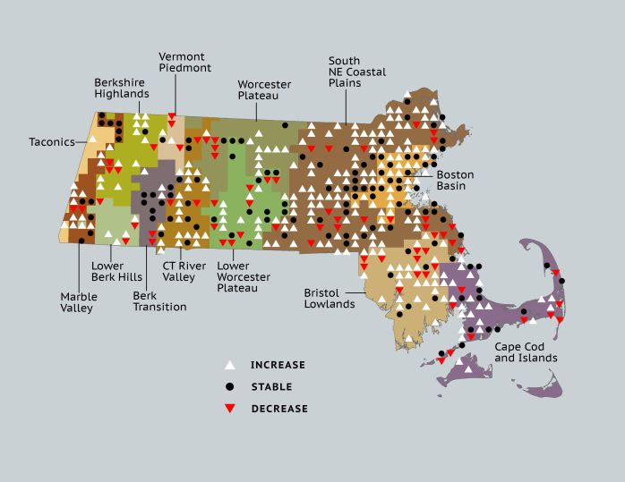
Ecoregion Data
Atlas 1 | Atlas 2 | Change | ||||||
Ecoregion | # Blocks | % Blocks | % of Range | # Blocks | % Blocks | % of Range | Change in # Blocks | Change in % Blocks |
Taconic Mountains | 0 | 0.0 | 0.0 | 2 | 8.0 | 0.4 | 2 | 13.3 |
Marble Valleys/Housatonic Valley | 14 | 35.9 | 6.7 | 22 | 56.4 | 4.9 | 8 | 20.5 |
Berkshire Highlands | 4 | 7.3 | 1.9 | 13 | 23.6 | 2.9 | 9 | 17.0 |
Lower Berkshire Hills | 3 | 10.7 | 1.4 | 6 | 19.4 | 1.3 | 2 | 7.4 |
Vermont Piedmont | 4 | 23.5 | 1.9 | 6 | 35.3 | 1.3 | -1 | -8.3 |
Berkshire Transition | 12 | 31.6 | 5.7 | 17 | 42.5 | 3.8 | 1 | 3.2 |
Connecticut River Valley | 13 | 23.2 | 6.2 | 35 | 53.8 | 7.8 | 17 | 35.4 |
Worcester Plateau | 11 | 14.1 | 5.2 | 29 | 33.0 | 6.5 | 7 | 14.6 |
Lower Worcester Plateau | 25 | 33.8 | 11.9 | 31 | 38.8 | 7.0 | 3 | 5.6 |
S. New England Coastal Plains and Hills | 60 | 22.2 | 28.6 | 157 | 55.5 | 35.2 | 70 | 31.0 |
Boston Basin | 20 | 35.7 | 9.5 | 46 | 82.1 | 10.3 | 25 | 45.5 |
Bristol and Narragansett Lowlands | 19 | 17.9 | 9.0 | 38 | 33.3 | 8.5 | 16 | 15.8 |
Cape Cod and Islands | 25 | 18.4 | 11.9 | 44 | 30.6 | 9.9 | 14 | 11.7 |
Statewide Total | 210 | 21.7 | 100.0 | 446 | 43.0 | 100.0 | 173 | 20.9 |