


Find a Bird
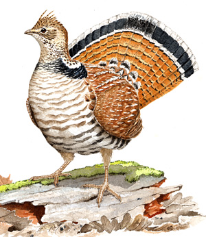
Ruffed Grouse
Bonasa umbellus
Fairly widespread and likely declining
Action/monitoring needed
State Wildlife Action Plan listed
“Everybody knows…that the autumn landscape in the north woods is the land, plus a red maple, plus a ruffed grouse.” – Aldo Leopold
The cryptically colored Ruffed Grouse is much more often heard than seen, particularly in the spring, when male grouse find a small hummock or fallen log and flap their wings rapidly to make the “drumming” sound for which this species is famous. Unlike the Ring-necked Pheasant, which favors brushy fields, the Ruffed Grouse is a bird of young forests. Alder is a particularly favored food because of its succulent buds and catkins, which help sustain grouse through the cold as they overwinter in Massachusetts. The spring woods of Massachusetts once echoed from the Cape to the Berkshires with the drumming of grouse, but whether that will be the case in the future remains an open question.
Historic Status
Thomas Morton, an early visitor to the New World, wrote in one of his accounts of life on the South Shore that he once saw 40 ruffed grouse in the same tree (Morton 1637). The wide-scale abandonment of farms, which led to abundant early-successional habitat, likely played a role in the flourishing of the Ruffed Grouse, with the nineteenth century probably witnessing its heyday. Unfortunately, the species became an orchard pest, and some towns actually placed bounties on grouse (Forbush 1912). By gunning and snaring, hunters took thousands of ruffed grouse in the latter half of the 1800s. These pressures, compounded by the decrease of farming and open farmland during the 1900s, likely contributed to the decline in the species’ population.
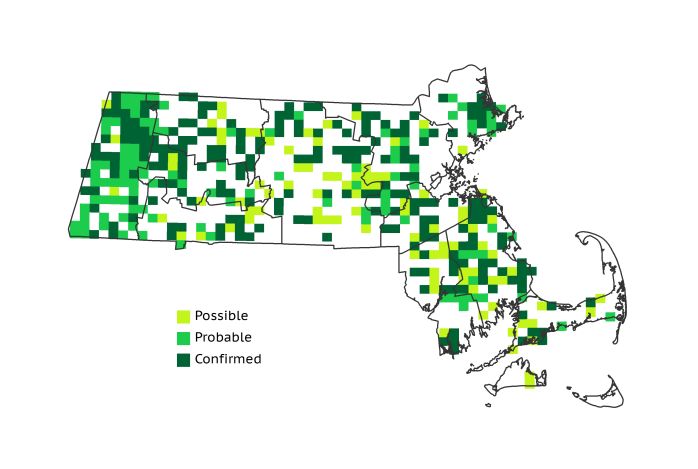
Atlas 1 Distribution
In Atlas 1 Ruffed Grouse were still widely distributed. Grouse were most commonly encountered in the extreme western part of the state, with birds found in more than half of all Taconic Mountains, Berkshire Highlands, and Berkshire Transition blocks. The number of occupied blocks decreased noticeably eastward through the Connecticut River Valley and the Worcester Plateau, though scattered blocks were nonetheless present in every ecoregion. Farther east, grouse were fairly widespread in the Coastal Plains and the Bristol/Narragansett Lowlands, but there were few occupied blocks in the densely settled Boston Basin or the sandy scrub habitats of the Cape and Islands.
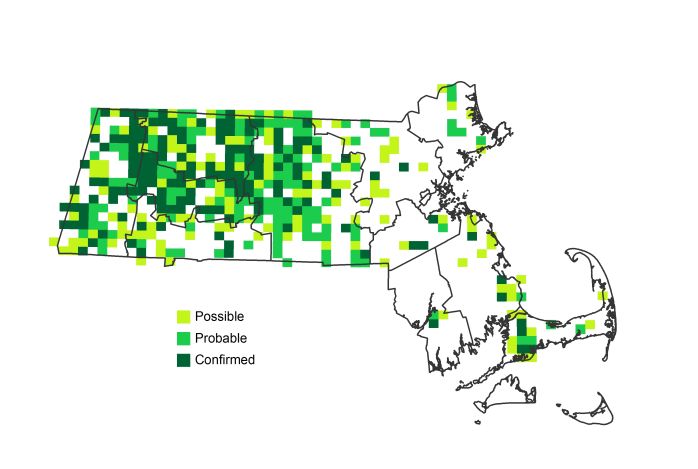
Atlas 2 Distribution and Change
The “heart attack bird,” as it is sometimes known by birders because of the startling and unexpected wing-whir heard when the species is flushed in the woods, was found in similar percentages of total blocks during both Atlas 1 and 2; 43% in Atlas 1, and just over 40% of the blocks in Atlas 2. However, there is hardly another species that has shown such a dramatic regional shift during the interval between Atlas 1 and 2. While an obvious retreat from the eastern half of the state occurred, block occupancy in the western part of the state strengthened. Looking at persistence and loss patterns in this species is instructional. This shift is likely most reflective of the ongoing development of the suburbs around Boston, in Essex, Middlesex, Suffolk, Norfolk, Plymouth, and Bristol Counties. On the other hand, forests in these areas are also maturing and are stringently protected, with little new growth from fire or other disturbance. Ruffed Grouse prefer a middle ground disallowed by either managed farmland or mature woods. Regularly burned or cut forest habitats with small trees and ground cover offer needed protections for breeding grouse. In central and western Massachusetts, where old farmlands are returning to forests more than they are becoming parking and housing lots, the species is holding on.
Atlas 1 Map
Atlas 2 Map
Atlas Change Map
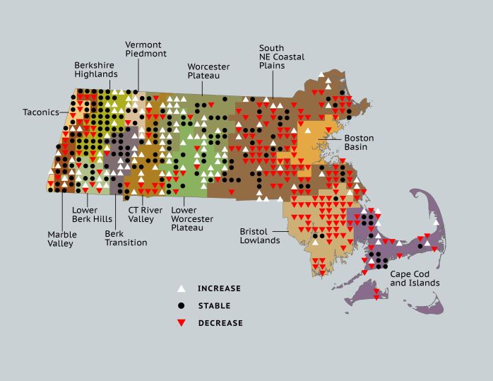
Ecoregion Data
Atlas 1 | Atlas 2 | Change | ||||||
Ecoregion | # Blocks | % Blocks | % of Range | # Blocks | % Blocks | % of Range | Change in # Blocks | Change in % Blocks |
Taconic Mountains | 13 | 81.3 | 3.1 | 12 | 48.0 | 2.9 | -5 | -33.3 |
Marble Valleys/Housatonic Valley | 29 | 74.4 | 6.9 | 28 | 71.8 | 6.7 | -1 | -2.6 |
Berkshire Highlands | 39 | 70.9 | 9.3 | 47 | 85.5 | 11.2 | 6 | 11.3 |
Lower Berkshire Hills | 15 | 53.6 | 3.6 | 20 | 64.5 | 4.8 | 3 | 11.1 |
Vermont Piedmont | 8 | 47.1 | 1.9 | 16 | 94.1 | 3.8 | 4 | 33.3 |
Berkshire Transition | 20 | 52.6 | 4.8 | 29 | 72.5 | 6.9 | 7 | 22.6 |
Connecticut River Valley | 25 | 44.6 | 6.0 | 31 | 47.7 | 7.4 | 2 | 4.2 |
Worcester Plateau | 31 | 39.7 | 7.4 | 75 | 85.2 | 17.9 | 19 | 39.6 |
Lower Worcester Plateau | 29 | 39.2 | 6.9 | 54 | 67.5 | 12.9 | 11 | 20.4 |
S. New England Coastal Plains and Hills | 119 | 44.1 | 28.4 | 76 | 26.9 | 18.2 | -55 | -24.3 |
Boston Basin | 9 | 16.1 | 2.1 | 1 | 1.8 | 0.2 | -8 | -14.5 |
Bristol and Narragansett Lowlands | 51 | 48.1 | 12.2 | 5 | 4.4 | 1.2 | -46 | -45.5 |
Cape Cod and Islands | 31 | 22.8 | 7.4 | 24 | 16.7 | 5.7 | -9 | -7.5 |
Statewide Total | 419 | 43.2 | 100.0 | 418 | 40.3 | 100.0 | -72 | -8.7 |