

Find a Bird
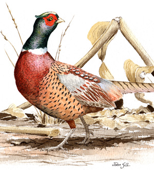
Ring-necked Pheasant
Phasianus colchicus
Local and strongly declining
“See! from the brake the whirring pheasant springs, / And mounts exulting on triumphant wings: / Short is his joy; he feels the fiery wound, / Flutters in blood, and panting beats the ground.” – Alexander Pope, “Windsor Forest”
Ring-necked Pheasants, originally from Asia, were introduced to Massachusetts in 1894. The landscape in the state at the time was dominated by old fields and brushy meadows, habitat that was perfect for Ring-necked Pheasants. They established themselves quickly as a breeding species and enjoyed a fairly robust population, largely because of the annual release of tens of thousands of farm-raised birds. Today, that population is no longer nearly as plentiful as it once was.
Historic Status
With the Ring-Necked Pheasant, unlike most other introduced species, Massachusetts ornithologists can pinpoint the exact time when and place where the introduction of a bird species into the state occurred. “In 1894, Mr. Sullivan Forehand of Worcester, Massachusetts, obtained a few pairs of breeding birds from Oregon,” (Forbush 1927), which he ultimately turned over to the state’s Commission on Fisheries and Game. The Oregon birds came from China and were part of a successful introduction there seven years earlier. Massachusetts built breeding pens in Winchester and began raising young birds for hunting. The abundance of farmland both at that time and on into the twentieth century allowed the birds to flourish. Even as farmland began to vanish in the state, perpetually restocked Ring-Necked Pheasants readily became adapted to the state's ever-sprawling suburban habitats.
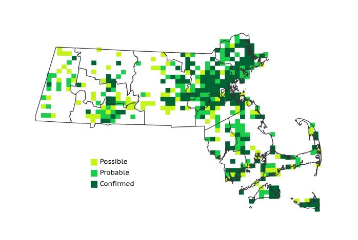
Atlas 1 Distribution
Ring-necked Pheasants were still fairly widespread in Massachusetts during Atlas 1. They were present at least in small numbers in all western ecoregions except the Lower Berkshire Hills, with the Marble Valleys reporting 46% occupancy. The Connecticut River Valley, so reminiscent of a pastoral Old World landscape, had 63% block occupancy. Ring-necked Pheasants were somewhat local but still present throughout the Worcester Plateau regions, and they edged over 50% block occupancy in the Coastal Plains. Surprisingly, the Boston Basin had the highest rate of occupancy in the state at 80%, possibly due to frequent releases by urban and suburban sportsmen. The birds were also fairly widespread in the Bristol/Narragansett Lowlands but slightly less so on Cape Cod, though the natural shrub and heathlands of the offshore islands hosted many pheasants.
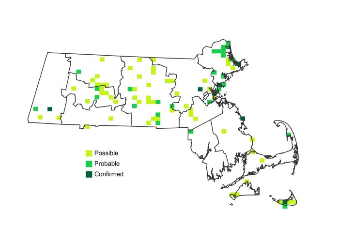
Atlas 2 Distribution and Change
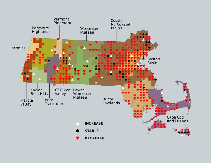
Thirty years later, the story changed completely for this species in Massachusetts. Pheasants never reached more than 18% block occupancy in any ecoregion during Atlas 2, and they were lost from 39% (326) of the blocks when we examine the blocks with the best survey data. Losses came in each ecoregion, except the Lower Berkshire Hills, and the pheasants’ footprint declined remarkably in the Marble Valleys (41%), Connecticut River Valley (46%), Coastal Plains (47%), Boston Basin (66%), Bristol Lowlands (47%), and Cape Cod and the Islands (38%) ecoregions. Habitat loss driven by the continuing reforestation of the Northeast reduced the Ring-necked Pheasant from a “common and widespread resident” in 1993 (Veit & Petersen 1993) to a relative rarity on most birders’ annual state lists by the end of the fieldwork for Atlas 2. MassWildlife restocks 40,000 birds annually (www.mass.gov/dfwele), but the loss of agricultural lands has now made Massachusetts an inhospitable place for this species, as evidenced by the mere scattering of sightings encountered through five breeding seasons of Atlas coverage.
Atlas 1 Map
Atlas 2 Map
Atlas Change Map
Ecoregion Data
Atlas 1 | Atlas 2 | Change | ||||||
Ecoregion | # Blocks | % Blocks | % of Range | # Blocks | % Blocks | % of Range | Change in # Blocks | Change in % Blocks |
Taconic Mountains | 2 | 12.5 | 0.5 | 0 | 0.0 | 0.0 | -2 | -13.3 |
Marble Valleys/Housatonic Valley | 18 | 46.2 | 4.5 | 2 | 5.1 | 2.2 | -16 | -41.0 |
Berkshire Highlands | 9 | 16.4 | 2.2 | 1 | 1.8 | 1.1 | -8 | -15.1 |
Lower Berkshire Hills | 0 | 0.0 | 0.0 | 2 | 6.5 | 2.2 | 2 | 7.4 |
Vermont Piedmont | 4 | 23.5 | 1.0 | 1 | 5.9 | 1.1 | -3 | -25.0 |
Berkshire Transition | 7 | 18.4 | 1.7 | 1 | 2.5 | 1.1 | -5 | -16.1 |
Connecticut River Valley | 35 | 62.5 | 8.7 | 10 | 15.4 | 11.1 | -22 | -45.8 |
Worcester Plateau | 14 | 17.9 | 3.5 | 10 | 11.4 | 11.1 | -6 | -12.5 |
Lower Worcester Plateau | 16 | 21.6 | 4.0 | 8 | 10.0 | 8.9 | -8 | -14.8 |
S. New England Coastal Plains and Hills | 146 | 54.1 | 36.1 | 31 | 11.0 | 34.4 | -106 | -46.9 |
Boston Basin | 45 | 80.4 | 11.1 | 10 | 17.9 | 11.1 | -36 | -65.5 |
Bristol and Narragansett Lowlands | 52 | 49.1 | 12.9 | 2 | 1.8 | 2.2 | -47 | -46.5 |
Cape Cod and Islands | 56 | 41.2 | 13.9 | 12 | 8.3 | 13.3 | -45 | -37.5 |
Statewide Total | 404 | 41.7 | 100.0 | 90 | 8.7 | 100.0 | -302 | -36.4 |
Notes
The Ring-necked Pheasant shows significant decreasing Breeding Bird Survey trends in Massachusetts, the New England/Mid-Atlantic region, and eastern US region.