

Find a Bird
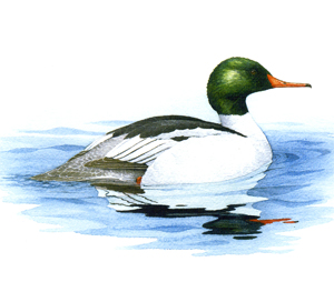
Common Merganser
Mergus merganser
Local and strongly increasing
“It can sink quietly down into the water like a grebe or dive quickly with a forward curving plunge, clearing the water for a foot or more, as it does so. It swims swiftly on the surface, but can attain even higher speed below it, where few fish can escape it.” – Arthur Cleveland Bent, Life Histories of North American Wild Fowl
While many of our breeding waterfowl head south at the first sign of winter, Common Mergansers are hardy birds and are usually among the last to leave fresh water as it begins to freeze. Extensive sheets of open freshwater containing plenty of fish attract Common Mergansers, and for nesting they seek tree cavities, nest boxes, or even appropriate locations on the ground. Because they feed extensively on fish captured in major waterways, Common Mergansers are vulnerable to waterborne pollutants that often concentrate in large river systems.
Historic Status
Edward Howe Forbush had high hopes for the Common Merganser. The “Goosander,” or “Sheldrake,” as it had been called, was regularly known to leave Massachusetts in April, although Audubon claimed they bred in the state in the 1830s. “Under the present law,” wrote Forbush at the beginning of the twentieth century, “which forbids spring shooting, it is quite possible that Sheldrakes will breed in New England in increasing numbers” (Forbush 1912). Overhunting, however, probably was the least of the species' worries. It took a hardy soul to eat a Common Merganser, which Forbush described as “about as palatable as a stewed kerosene lamp wick” (Forbush 1912). During the 1900s, it wasn't guns that kept the Sheldrake in check as a Massachusetts breeder, but instead it was the comparably peaceable depredations of humankind through encroachment on the species’ breeding habitat that made the state inhospitable for nesting.
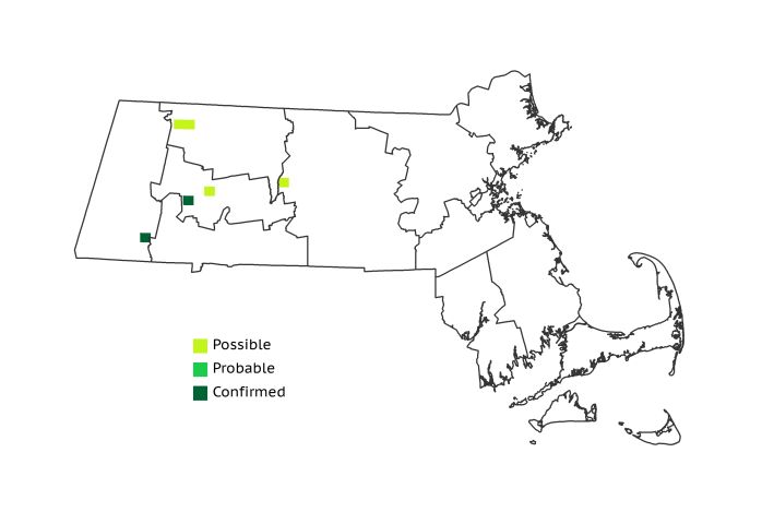
Atlas 1 Distribution
In Atlas 1, piscivorous Common Mergansers were found in just a few locales in the state. As history reminds us, mergansers were always scarce breeders in the Bay State, mainly limited to the large rivers of the western hill country such as the Deerfield and the Westfield, as well as a single Possible block at Quabbin Reservoir. Only 6 total occupied blocks were reported: 2 from the Berkshire Highlands, 2 in the Berkshire Transition, 1 in the Lower Berkshire Hills, and 1 in a Quabbin block in the Lower Worcester Plateau. The Connecticut River Valley was notably devoid of Common Mergansers.
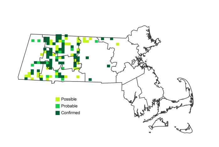
Atlas 2 Distribution and Change
While still patchily distributed in Massachusetts, Common Mergansers were exceptionally successful in their colonization of the central and western regions of the state. Records for Atlas 2 are mostly confined to regions west of the Coastal Plains, but it is likely that their spread will continue eastward in areas where suitable habitat and ample food persist. The regions west of the Coastal Plains post impressive gains in new block occupancy – from 6% to 50% and the Vermont Piedmont showing almost 60% (7) of the blocks occupied.
Atlas 1 Map
Atlas 2 Map
Atlas Change Map

Ecoregion Data
Atlas 1 | Atlas 2 | Change | ||||||
Ecoregion | # Blocks | % Blocks | % of Range | # Blocks | % Blocks | % of Range | Change in # Blocks | Change in % Blocks |
Taconic Mountains | 0 | 0.0 | 0.0 | 1 | 4.0 | 0.9 | 1 | 6.7 |
Marble Valleys/Housatonic Valley | 0 | 0.0 | 0.0 | 5 | 12.8 | 4.5 | 5 | 12.8 |
Berkshire Highlands | 2 | 3.6 | 33.3 | 16 | 29.1 | 14.3 | 13 | 24.5 |
Lower Berkshire Hills | 1 | 3.6 | 16.7 | 9 | 29.0 | 8.0 | 8 | 29.6 |
Vermont Piedmont | 0 | 0.0 | 0.0 | 11 | 64.7 | 9.8 | 7 | 58.3 |
Berkshire Transition | 2 | 5.3 | 33.3 | 19 | 47.5 | 17.0 | 13 | 41.9 |
Connecticut River Valley | 0 | 0.0 | 0.0 | 18 | 27.7 | 16.1 | 14 | 29.2 |
Worcester Plateau | 0 | 0.0 | 0.0 | 17 | 19.3 | 15.2 | 9 | 18.8 |
Lower Worcester Plateau | 1 | 1.4 | 16.7 | 12 | 15.0 | 10.7 | 8 | 14.8 |
S. New England Coastal Plains and Hills | 0 | 0.0 | 0.0 | 4 | 1.4 | 3.6 | 4 | 1.8 |
Boston Basin | 0 | 0.0 | 0.0 | 0 | 0.0 | 0.0 | 0 | 0.0 |
Bristol and Narragansett Lowlands | 0 | 0.0 | 0.0 | 0 | 0.0 | 0.0 | 0 | 0.0 |
Cape Cod and Islands | 0 | 0.0 | 0.0 | 0 | 0.0 | 0.0 | 0 | 0.0 |
Statewide Total | 6 | 0.6 | 100.0 | 112 | 10.8 | 100.0 | 82 | 9.9 |