

Find a Bird
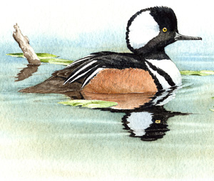
Hooded Merganser
Lophodytes cucullatus
Somewhat local and strongly increasing
“Is that a marshmallow on your head?” – Jane Yolen, Birds of a Feather
The drake Hooded Merganser cuts an unmistakable figure as it glides across the surface of a woodland pond with its white hood held high. Under that hood is an unusual species of waterfowl that catches fish in a sawtooth bill and makes its nest in a hollow tree. As the trees it nested in were steadily felled for agriculture and development, the Hooded Merganser was forced to retreat to the few wooded wetlands remaining in the heart of the state to wait for a more auspicious time. That time, it would seem, has come.
Historic Status
The swiftly flying little Hooded Merganser surely suffered from the loss of forest habitat when European settlers worked over the Massachusetts landscape for farming, but whether or not Hooded Mergansers bred here prior to Audubon's travels in America in the early to mid-1800s is based on supposition (Phillips 1922). Early Massachusetts habitat was conducive to breeding because this species, like the Wood Duck, is dependent upon tree cavities for nesting. The status of the Hooded Merganser by the late 1800s was that of a common migrant; however, by the beginning of the next century, hunters had altered its status to that of an uncommon to rare migrant (Howe & Allen 1901). The regrowth of forests during the middle of the twentieth century provided the breeding habitat needed by Hooded Mergansers, and by the 1970s local waterfowl fanciers began to get glimpses of what was probably a common pre Colonial Massachusetts sight – Hooded Merganser ducklings jumping from their nest holes in tall snags and heading for nearby ponds.
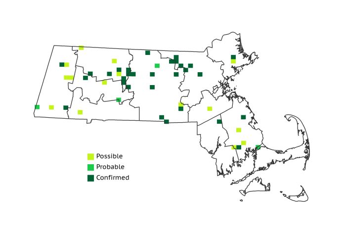
Atlas 1 Distribution
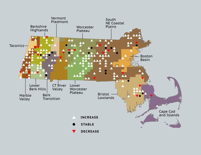
While there were scattered reports during Atlas 1 of breeding Hooded Mergansers as far west as the Taconic Mountains, the birds were quite scarce throughout the western part of the state, with no more than 4 occupied blocks in any western ecoregion. The species’ center of distribution at the time of Atlas 1 was the Quabbin area, located at the scenic juncture of the Worcester Plateau and Lower Worcester Plateau regions. These two ecoregions accounted for about a third of all occupied blocks in Atlas 1. The Coastal Plains also had a good number of breeding Hooded Mergansers, likely due in part to the prevalence of nest boxes erected for Wood Ducks. The Bristol/Narragansett Lowlands also had a handful of occupied blocks, but the Cape and Islands only had 1.
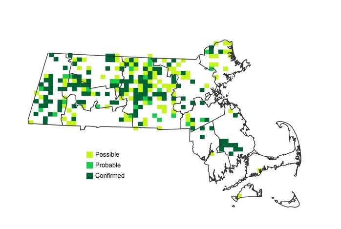
Atlas 2 Distribution and Change
Atlas 2 chronicled an expanding footprint for this species throughout most of the state, save for the Boston Basin and points south and east of there. While “Hoodies” were not detected in 20+ blocks where they were found during Atlas 1, these losses were more than offset by impressive gains in many new blocks. From 49 blocks in Atlas 1 to 260 blocks in Atlas 2, this bird’s colonization has been impressive, and many aspects of its spread are tied directly to conservation practices. Like other mergansers, Hooded Mergansers eat fish, crustaceans, and aquatic insects so that, as water quality has improved in many areas, it is likely that prey populations have increased as well. Local and national nest box programs designed to help Wood Duck populations recover have also aided the cavity-nesting Hooded Merganser. Similarly, the tremendous recovery of beavers across the state has created potential nesting habitat for many waterfowl species, the Hooded Merganser among them (McCall et al 1996).
Atlas 1 Map
Atlas 2 Map
Atlas Change Map
Ecoregion Data
Atlas 1 | Atlas 2 | Change | ||||||
Ecoregion | # Blocks | % Blocks | % of Range | # Blocks | % Blocks | % of Range | Change in # Blocks | Change in % Blocks |
Taconic Mountains | 1 | 6.3 | 2.0 | 3 | 12.0 | 1.2 | 2 | 13.3 |
Marble Valleys/Housatonic Valley | 2 | 5.1 | 4.1 | 18 | 46.2 | 6.9 | 16 | 41.0 |
Berkshire Highlands | 4 | 7.3 | 8.2 | 24 | 43.6 | 9.2 | 18 | 34.0 |
Lower Berkshire Hills | 1 | 3.6 | 2.0 | 10 | 32.3 | 3.8 | 8 | 29.6 |
Vermont Piedmont | 0 | 0.0 | 0.0 | 2 | 11.8 | 0.8 | 1 | 8.3 |
Berkshire Transition | 3 | 7.9 | 6.1 | 18 | 45.0 | 6.9 | 10 | 32.3 |
Connecticut River Valley | 1 | 1.8 | 2.0 | 8 | 12.3 | 3.1 | 2 | 4.2 |
Worcester Plateau | 10 | 12.8 | 20.4 | 46 | 52.3 | 17.7 | 15 | 31.3 |
Lower Worcester Plateau | 5 | 6.8 | 10.2 | 36 | 45.0 | 13.8 | 24 | 44.4 |
S. New England Coastal Plains and Hills | 15 | 5.6 | 30.6 | 75 | 26.5 | 28.8 | 47 | 20.8 |
Boston Basin | 0 | 0.0 | 0.0 | 4 | 7.1 | 1.5 | 4 | 7.3 |
Bristol and Narragansett Lowlands | 6 | 5.7 | 12.2 | 12 | 10.5 | 4.6 | 6 | 5.9 |
Cape Cod and Islands | 1 | 0.7 | 2.0 | 4 | 2.8 | 1.5 | 2 | 1.7 |
Statewide Total | 49 | 5.1 | 100.0 | 260 | 25.1 | 100.0 | 155 | 18.7 |