

Find a Bird
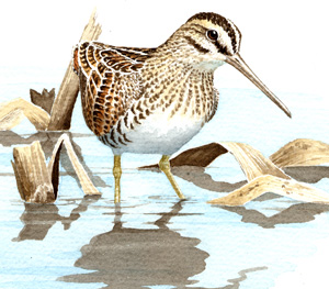
Wilson's Snipe
Gallinago delicata
Local and likely increasing
“Occasionally I spot one far up in the ruddy evening sky, zig-zagging across the darkening water. Even when bound for some definite objective this bird finds it impossible to travel in a straight line.” – Henry Marion Hall, A Gathering of Shore Birds
The old notion of a “snipe hunt,” wherein experienced outdoorsmen would send gullible newcomers into the forest on a fool’s errand, has some basis in truth. As they are cryptically colored and prefer to nest in grassy wetlands, finding and bagging a Wilson’s Snipe (or its Old World counterpart, the Common Snipe) is quite a feat. Shooting one of these birds is so difficult that the name given to the eighteenth-century master sharpshooters of British India was “snipers.” In Massachusetts, the Wilson’s Snipe has been pursued avidly by sportsmen for many years, and today there remains only a shadow of its former population.
Historic Status
Hunters in Massachusetts shot the Wilson's Snipe by the bagful in the 1800s, and eventually their work thinned its population. “It is well known to sportsmen,” wrote William Peabody, “who take advantage of its local attachment, and by ascertaining its favorite resorts, are able to shoot large numbers,” (Peabody 1839). Spring shooting, in particular, depressed the population, and by the early 20th century, Edward Howe Forbush said, “In some of the localities where I shot Snipe thirty to forty years ago not one is ever seen now,” (Forbush 1912). Still, throughout the twentieth century, the species could be found in Massachusetts during migration, though its presence during the summer was much reduced.
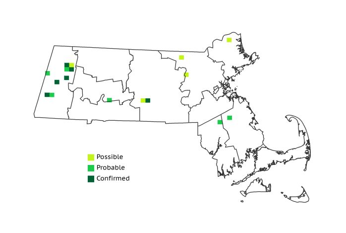
Atlas 1 Distribution
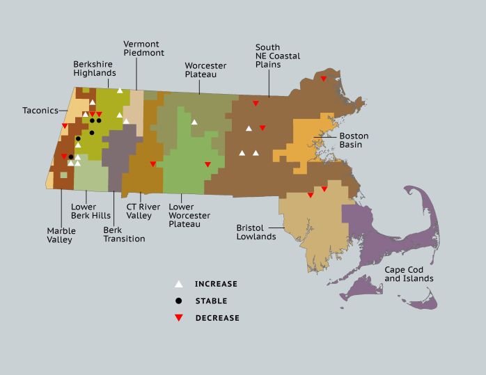
Less often hunted in the 1970s than historically, snipe were already scarce during the breeding season by the time of Atlas 1. They were most often found in the high hills of the Berkshire and Taconic region, where the high-elevation bogs most closely resembled their more typical boreal wetland breeding areas. Six out of 17 records occurred in the Berkshire Highlands region, with a few more in the Taconic Mountains and Marble Valleys. Farther east in the state, evidence of breeding Wilson’s Snipes was thin. A Probable record in the Connecticut River Valley and a pair of occupied blocks in the Lower Worcester Plateau were the only signs of the snipe’s presence in central Massachusetts. No breeding was Confirmed anywhere in eastern Massachusetts, but a handful of occupied blocks suggested that breeding may have been still occurring in small numbers in secluded marshes.
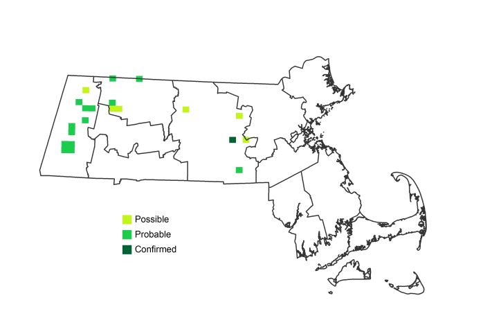
Atlas 2 Distribution and Change
The Wilson’s Snipe was still a rare and local summer resident and breeding bird in Atlas 2 that was only found at a few scattered locations; the greatest concentration of snipes was in the Berkshire Highlands region. The Wilson’s Snipe arrives fairly early on its breeding grounds, and is easiest to detect when giving its aerial “winnowing” display. This behavior may explain why a high percentage of sightings were coded as Probable breeding locations. Notoriously difficult to positively Confirm, snipes were found during Atlas 2 in several blocks in more than one year, but were only Confirmed once. Unfortunately, the difficulty in Confirming this cryptically plumaged species allows for little accurate assessment of how many of these courting birds are actually breeding successfully. However, their persistence in some blocks year after year suggests that this might represent an opportunity to assess their breeding status with surveys other than those used during the Breeding Bird Atlas.
Atlas 1 Map
Atlas 2 Map
Atlas Change Map
Ecoregion Data
Atlas 1 | Atlas 2 | Change | ||||||
Ecoregion | # Blocks | % Blocks | % of Range | # Blocks | % Blocks | % of Range | Change in # Blocks | Change in % Blocks |
Taconic Mountains | 1 | 6.3 | 5.9 | 0 | 0.0 | 0.0 | -1 | -6.7 |
Marble Valleys/Housatonic Valley | 2 | 5.1 | 11.8 | 3 | 7.7 | 14.3 | 1 | 2.6 |
Berkshire Highlands | 6 | 10.9 | 35.3 | 8 | 14.5 | 38.1 | 1 | 1.9 |
Lower Berkshire Hills | 0 | 0.0 | 0.0 | 3 | 9.7 | 14.3 | 3 | 11.1 |
Vermont Piedmont | 0 | 0.0 | 0.0 | 1 | 5.9 | 4.8 | 1 | 8.3 |
Berkshire Transition | 0 | 0.0 | 0.0 | 0 | 0.0 | 0.0 | 0 | 0.0 |
Connecticut River Valley | 1 | 1.8 | 5.9 | 0 | 0.0 | 0.0 | -1 | -2.1 |
Worcester Plateau | 0 | 0.0 | 0.0 | 2 | 2.3 | 9.5 | 1 | 2.1 |
Lower Worcester Plateau | 2 | 2.7 | 11.8 | 0 | 0.0 | 0.0 | -1 | -1.9 |
S. New England Coastal Plains and Hills | 3 | 1.1 | 17.6 | 4 | 1.4 | 19.0 | 0 | 0.0 |
Boston Basin | 0 | 0.0 | 0.0 | 0 | 0.0 | 0.0 | 0 | 0.0 |
Bristol and Narragansett Lowlands | 2 | 1.9 | 11.8 | 0 | 0.0 | 0.0 | -2 | -2.0 |
Cape Cod and Islands | 0 | 0.0 | 0.0 | 0 | 0.0 | 0.0 | 0 | 0.0 |
Statewide Total | 17 | 1.8 | 100.0 | 21 | 2.0 | 100.0 | 2 | 0.2 |