


Find a Bird
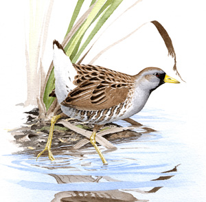
Sora
Porzana carolina
Local and likely increasing
State Wildlife Action Plan listed
“One day, you may see or hear the Soras in their favourite marshes, you may be aware of their presence in the dusk of evening; but when you return to the place early next morning, they are all gone.” – John James Audubon, Birds of America
In spring, freshwater marshes from the Pacific Northwest all the way to New England resound with the distinctive descending whinnies of Soras. These rails are the smallest of their ilk in Massachusetts, populating our wetlands during both migration and throughout the breeding season. Darkly feathered and short billed, they bear only a general physical resemblance to our other breeding rail species, yet they share the same secretive habits and preferences for thickly vegetated wetland habitats.
Historic Status
“The Sora is the Rail-Bird of New England,” Edward Howe Forbush declared in his Birds of Massachusetts and Other New England States in 1925. And this was certainly the case, despite the best efforts of hunters who took as many as 181 in a day, according to one report (Forbush 1913). The Connecticut River Valley was a favored hunting spot for the bird; in 1908, one reporter tallied 1,000 shot in Longmeadow alone (Forbush 1912). Favored for hunting over Clapper Rails, especially during fall migration when the rails were plump from feasting on wild rice, the birds suffered a drop in population as the century progressed. This decline was compounded by wetland degradation and subsequent habitat loss. Modern birders pine for the days when small flocks of Soras would “surround a recumbent duck hunter and even peck at his clothing” (Forbush 1912).
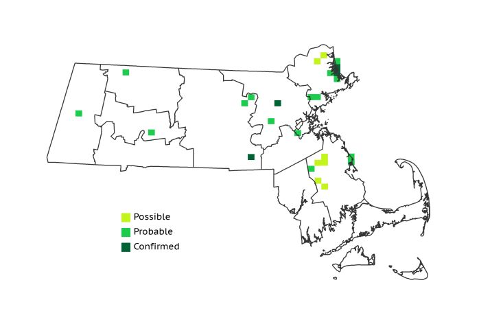
Atlas 1 Distribution
In a relatively small and crowded state like Massachusetts, the sort of extensive marsh habitat required by Soras is always at a premium. A handful of Probable blocks in the Berkshire Highlands and Connecticut River Valley represented the only Sora activity reported for the western half of the state in Atlas 1. The birds were marginally more abundant in the eastern regions, especially the Coastal Plains, which accounted for more than half of all occupied blocks in the state. Many of these were concentrated around protected wetlands such as the Great Meadows and Parker River National Wildlife Refuges. A handful of sightings around the Boston Basin and a half-dozen Possible and Probable blocks in the Bristol/Narragansett Lowlands represented the only other evidence found of breeding Soras.
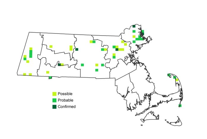
Atlas 2 Distribution and Change
Whether they were missed in the 1970s or have only recently appeared, the fact remains that Soras were present in more than a dozen western blocks in Atlas 2, mostly in the Marble Valleys where they had previously been absent. Small gains in several other western and central regions suggested that, if Soras were not truly increasing in Massachusetts, they had at the very least maintained a stable presence during the inter-Atlas period. The signs were also encouraging in the Coastal Plains, where Soras appeared in almost twice as many blocks as they vanished from. The same could not be said of the Bristol/Narragansett Lowlands, where the species apparently disappeared completely as a breeder between Atlases 1 and 2. A loss of cattail marsh habitat seems a likely contributor to this apparent local extinction, which is a definite cause for concern. Conversely, the arrival of breeding Soras on Cape Cod implies that our smallest rail is still managing to make a living where proper habitat exists. That said, these modest gains should not be viewed as recovery for this species, since their numbers are still a fraction of their early twentieth-century numbers.
Atlas 1 Map
Atlas 2 Map
Atlas Change Map
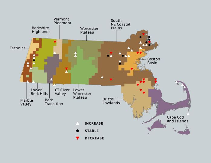
Ecoregion Data
Atlas 1 | Atlas 2 | Change | ||||||
Ecoregion | # Blocks | % Blocks | % of Range | # Blocks | % Blocks | % of Range | Change in # Blocks | Change in % Blocks |
Taconic Mountains | 0 | 0.0 | 0.0 | 0 | 0.0 | 0.0 | 0 | 0.0 |
Marble Valleys/Housatonic Valley | 0 | 0.0 | 0.0 | 6 | 15.4 | 12.5 | 6 | 15.4 |
Berkshire Highlands | 2 | 3.6 | 7.7 | 2 | 3.6 | 4.2 | 0 | 0.0 |
Lower Berkshire Hills | 0 | 0.0 | 0.0 | 1 | 3.2 | 2.1 | 1 | 3.7 |
Vermont Piedmont | 0 | 0.0 | 0.0 | 1 | 5.9 | 2.1 | 1 | 8.3 |
Berkshire Transition | 0 | 0.0 | 0.0 | 1 | 2.5 | 2.1 | 1 | 3.2 |
Connecticut River Valley | 1 | 1.8 | 3.8 | 3 | 4.6 | 6.3 | 1 | 2.1 |
Worcester Plateau | 0 | 0.0 | 0.0 | 4 | 4.5 | 8.3 | 2 | 4.2 |
Lower Worcester Plateau | 0 | 0.0 | 0.0 | 2 | 2.5 | 4.2 | 0 | 0.0 |
S. New England Coastal Plains and Hills | 14 | 5.2 | 53.8 | 23 | 8.1 | 47.9 | 5 | 2.2 |
Boston Basin | 3 | 5.4 | 11.5 | 1 | 1.8 | 2.1 | -2 | -3.6 |
Bristol and Narragansett Lowlands | 6 | 5.7 | 23.1 | 0 | 0.0 | 0.0 | -6 | -5.9 |
Cape Cod and Islands | 0 | 0.0 | 0.0 | 4 | 2.8 | 8.3 | 4 | 3.3 |
Statewide Total | 26 | 2.7 | 100.0 | 48 | 4.6 | 100.0 | 13 | 1.6 |